
HOA Management in Denver, NC
William Douglas Management is a leader in customer service — the experience and expertise that your association needs and deserves!
Denver is an unincorporated area in eastern Lincoln County
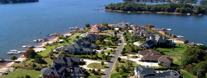
Situated on the western shores of Lake Norman, the town of Denver offers a quieter option for lakeside living than the more populated towns across the lake.
Residents describe Denver as laid-back, edging on rural, but with all of the accoutrements of living in close proximity to North Carolina’s largest city. William Douglas Property Management understands this balance between modern convenience and rural charm, and can help your Denver-based HOA achieve its vision.
About Denver, NC
Denver, North Carolina, is an unincorporated area in eastern Lincoln County. Because Denver is unincorporated with no defined borders, the residents refer to a huge area along Business North Carolina State Highway 16 as Denver. Denver’s zip code also covers a large area of eastern Lincoln County and a small portion of Catawba County.
Denver has developed into a bedroom community for Charlotte beginning in the late 1990s. From the 1960s, when Lake Norman was constructed through the 1980s, Denver developed into a weekend lake and entertainment destination. Before 1960, the Denver area was a rural community with around 400 homes. Today there are over 8,000 homes in the area that is considered Denver.
Denver was originally known as Dry Pond. In 1873, Dry Pond was renamed Denver. The new community’s name was reportedly derived from Denver, Colorado. This new name was reportedly chosen to help attract the railroad to come through the community. Denver was incorporated by the North Carolina General Assembly in 1877; however, this incorporation charter was revoked by the General Assembly in 1971.
The borders of the original Denver are a strongly debated topic with the locals, especially with the long-term residents. Most agree that the intersection on Business North Carolina Highway 16 and Campground Road is the heart of the original community. Sitting at this intersection is one of the oldest restaurants in the area, Stacy’s. First Federal Savings Bank, Denver Furniture Center, and the Denver Mart make up the other corner establishments at this intersection.
The Rock Springs Campground on Campground Road was founded in 1830. The Campground has hosted an annual camp meeting and gospel singing for parishioners from area churches every summer.
While not an incorporated municipality, Denver has many of the same traditions of formally established towns and cities. There is an Independence Day Parade, more commonly known as the Fourth of July Parade, held every year that’s route goes through the entire community. In September each year, the Denver Days festival is held. The festival includes carnival rides and an abundance of vendors offering an array of foods. Every May, Denver hosts the Strawberry Festival.
The United States Census Bureau classifies the Denver area as a census-designated place (CDP), being that it is an unincorporated community. A census-designated place does not have legally filed or defined borders other than what is established by the U.S. Census Bureau. The census-designated place total area for Denver, as established by the U.S. Census Bureau for 2010, was 5.9 square miles. Of this 5.9 square miles, 5.89 square miles is land, and the remaining 0.01 is water.
The census-designated place population, per the 2010 U.S. Census, was 2,309. Contrasting the CDP population total, the U.S. Census population for Denver’s zip code, 28037, totaled 18,287 for 2019. This 2019 zip code data also calculated 8,266 dwellings, with a median home value of $276,400, along with a median household income of $73,078.
Denver’s zip code is 28037.
The area code for Denver is 704.
The Coordinates for Denver are Latitude: 35°32′09.58″N, Longitude: 81°01′47.77″W per Google Earth.
Elevation per Google Earth: 877 feet.
Key Demographics per the United States Census Bureau for Denver’s Zip Code, 2019
Median Age: 41 years
Male population: 9,100 / 50% of population.
Female population: 9,187 / 50% of population.
High school graduate or higher 2015-2019: 95.0%
Bachelor’s degree or higher 2015-2019: 48.0%
Geography – Denver is located on the western shores of Lake Norman. The older and established areas of Denver are located on what is now known as Business North Carolina State Highway 16. The “new” State Highway 16 is a four-lane highway through Denver. Both “Business” and “New” NC State Highways travel in north and south directions, Mecklenburg County to the south and Catawba County to the north. Downtown Charlotte in Mecklenburg County is approximately 29 miles, roughly a forty-five-minute non-rush hour drive, or up to an hour and five minutes during typical rush hours. Hickory in Catawba County is approximately 27 miles, roughly a forty-minute drive. Lincolnton, the county seat of Lincoln County, is approximately 15 miles, roughly a twenty-five-minute drive. Mooresville in Iredell County to the east is approximately 19 miles, roughly a thirty-minute non-rush hour drive, or up to an hour during high traffic time periods.
An Overview of the History of Denver and Other Interesting Points
Archaeological sites in the region have uncovered artifacts and other evidence indicating Native American inhabitants dating back thousands of years. The fertile lands located within the Catawba River Basin are believed to have been habituated by Native Americans going back for at least 5,000 years. The first documented inhabitants of the Lincoln County area were the Cherokee and Catawba Indians. The Catawba River was the territorial border between these two Native American tribes.
This early documentation originates from the 1540 expedition of Spanish explorer Hernando de Soto. While de Soto’s exact route is unknown, it is believed the expedition entered North Carolina southwest of present-day Charlotte and traveled north to the Native American town of Guaquili, which is believed to have been near present-day Hickory. So, it is surmised that the expedition passed through present-day Lincoln County on the way to Guaquili.
The Catawba and Cherokee Indians and the region were chronicled in writings of the expedition. The semi-anonymous work by a man with the nom de guerre of a Gentleman of Elvas. He was reportedly a Portuguese knight who was a member of the expedition, and his work was first published in 1557. Spanish King Charles I’s factor, Luys Hernández de Biedma, compiled a detailed report of the expedition he submitted to the King’s court in 1544. Today, the original report is on file in Spain’s national archives.
De Soto’s secretary, Rodrigo Ranjel, kept a journal of the expedition. This expedition journal was utilized by Gonzalo Fernández de Oviedo y Valdés when he wrote La historia general y natural de las Indias. The parts of his writings sourced from Ranjel’s journal were published in 1851.
The next to document the Native Americans in Lincoln County was Spanish explorer Juan Pardo in 1567. Pardo’s exact route, while not definitive, is more determinable than de Soto’s route. Pardo’s expedition and his encounters with Native Americans were recounted in Vandera’s narratives of Pardo’s expedition.
Vandera describes a village named Ysa near present-day Lincolnton in Lincoln County. The expedition stayed here for an extended period of time, finding cassiterite, mica, feldspar, garnet, and spodumene.
Not much is known about any Native Americans who may have habituated the area where present-day Denver is located. Especially as compared to other areas in the region where archaeological evidence is more prevalent. What can be surmised is that the Catawba River area where Denver is located was fertile land. The area would have been suitable and abundant to support a large number of Native American inhabitants.
While intertribal wars and conflicts between colonists reduced the Native American population, nothing had the effect that smallpox did. The introduction of European diseases that Native Americans had no natural built-up immunities to devastated their population. This was particularly the case with smallpox. It is believed the first smallpox epidemic to strike the Native American population was in 1633 in Plymouth, Massachusetts.
Native Americas in the Carolina colony and other colonies were ravaged by the smallpox outbreaks of the 1700s. Before the colonial period, it is surmised that there were around 25,000 Catawba Indians and an equal number of Cherokee Indians in the Carolina colony. The Catawba population had been reduced to around 400 by 1775. Even though most surviving Native American tribes eagerly adopted the smallpox vaccine when it came into widespread use in the early 1880s, the prior outbreaks have not yet been overcome. The Catawba Indian people had only rebounded to around 2,600 members by the 2010 U.S. Census.
European settlers began arriving in the region in greater numbers as the Native American population declined during the 1700s. These immigrants to Piedmont were mostly German Palatines (Pennsylvania Dutch) and Scot-Irish. Starting in the 1740s, these settlers began arriving primarily by the Great Wagon Road from Pennsylvania. These settlers, for the most part, were subsistence farmers.
Reportedly, the first settlers of the present-day Denver area were Adam Sherrill and his eight sons from Pennsylvania in 1747. They were reportedly followed by John Beatty in 1749. The Sherrill and Beatty families established homes along the west bank of the Catawba River close to river fords. Fords were shallow river points that allowed for crossing. Thus, these fords soon became known as Sherrill’s Ford and Beatie’s Ford. These two location names are still in use in the Denver area today.
The general area where Denver is considered to be today was settled around 1770. Consistent with the immigration composition of the entire region, these early settlers to Denver were mostly Scotch-Irish and the German Palatines.
The Presbyterians have been the one constant in the future Denver since the original settlement. The Scotch-Irish settlers were mostly Presbyterians. John Beatty’s home, which reportedly stood a mile west of Beatty’s Ford on the Catawba River, was the Presbyterian’s first place of worship. This congregation is what would eventually become the Unity Presbyterian Church USA and was first established as Beattie’s Meeting House in 1764. The first Presbyterian meeting house was constructed of logs near a grove of oak and hickory trees beside a spring. The first pastor of record was Reverend Humphries Hunter, who arrived in 1796. Reverend Hunter had served in the American Revolutionary War with distinction. As the Presbyterian congregation increased in size, a larger meetinghouse was constructed in 1808. The pastor during this expansion was Reverend Henry N. Pharr. The next pastor was Reverend Patrick Sparrow. Reverend Sparrow became the professor of languages at Davidson College and later president of Hampton-Sidney College.
The population in the area continued to increase, and so did the Presbyterian congregation. The 1808 Presbyterian church structure was replaced in 1833 by a larger church. This church was a clapboard structure with an elevated pulpit in front of the nave for the congregation, with a gallery in the back for slaves. This 1833 church stood for almost 100 years when a new larger church was completed in 1931, which included nine Sunday school rooms. This structure still stands and is now known as the chapel, as it was replaced in 2005 by a new larger sanctuary that seats over 300 parishioners.
The cemetery at Unity Presbyterian is one of the oldest in the area. The oldest gravestone dates to 1777. The most prominent person buried at Unity is the 22nd Governor of North Carolina, Hutchins Gordon Burton (1774-1836). Unity Presbyterian Church is located at 8210 Unity Church Rd, Denver, North Carolina.
The Lincoln County area was a hotbed of resistance to the British Crown during the American Revolution (1775-1783). There were two important engagements in Lincoln County during the Revolution, the Battle of Ramsour’s Mill in 1780 and the Battle of Cowan’s Ford in 1781. While neither battle was a major engagement like the Battle of Cowpens or the Battle of Kings Mountain, the battles did have moral ramifications with those loyal to the British Crown.
Ramsour’s Mill was located in present-day Lincolnton, Lincoln County, and was the site of a loyalist, or Tories) gathering of men who were attempting to join the British forces against the patriots. On June 20, 1780, a short battle ensued when patriot forces attacked their encampment at Ramsour’s Mill. The patriots succeeded in their efforts to dislodge the loyalist encampment. The much larger effect resulting in the aftermath of this bloody engagement was that loyalist support in the area dwindled.
Six months later, in January of 1781, Lord Charles Cornwallis (1738 – 1805), commanding general of British forces in the south, arrived at Ramsour’s Mill and bivouacked his forces. It can be said that the American Revolutionary War was decided at Ramsour’s Mill when Cornwallis made the faithful decision to burn his heavy supply wagons. “He informs that some Spy brings Intelligence to the British Every Day from us, The Object in their View in Salisbury & that they Burned 100 Wagons & a Quantity of Salt & flour at Ramsours Mill.” (Farmer 1781 in PGNG 1997, VII:228)
Cornwallis burned his heavy supply wagons in an attempt to make his force nimbler to catch American Continental Army Major General Nathanael Greene (1742 – 1786). Greene’s Continental forces and patriot militia forces were utilizing hit and run tactics against the British throughout the Carolinas. Cornwallis was hoping to catch up with Greene and win a decisive battle to bring the war in the south to a conclusion. Cornwallis engaged with Greene’s forces at Guilford Courthouse in Guildford County, North Carolina. This became known as the Battle of Guilford Courthouse and turned out to be a Pyrrhic victory for the British. Because Cornwallis failed to decisively defeat Greene’s forces, he had to cease his pursuit of Green’s forces and divert to Hillsborough, North Carolina, to resupply his forces. This inability to push his pursuit of Greene’s forces eventually led to Cornwallis surrendering at Yorktown on October 19, 1781, and the eventual patriot victory.
Before Yorktown and before Guilford Courthouse, there was the Battle of Cowan’s Ford. Torrential rains had begun when Cornwallis broke camp at Ramsour’s Mill on January 31, 1781. The heavy rains resulted in a mud-clogged road with swollen streams and rivers along the route. Nonetheless, Cornwallis’ force moved out towards present-day Denver, on much the same route that present-day North Carolina Highway 73 follows today. The urgency of the march being that Greene’s forces were within Cornwallis’ grasp.
After the roughly 19-mile arduous march and passing through what is considered the lower part of present-day Denver, the British force arrived at Cowan’s Ford on January 31, 1781. The British force consisted of just under 2,500 men. Cornwallis instructed Lieutenant Colonel Webster to create a diversion upriver at Beatty’s Ford while his main force crossed at Cowan’s Ford.
The Battle of Cowan’s Ford occurred on February 1, 1781. Cowan’s Ford was a river crossing of the Catawba River east of present-day Denver. Cowan’s Ford and the center of the Catawba River is the county line between Lincoln and Mecklenburg counties. Today, the hydroelectric Duke Energy Cowan’s Ford Dam is located directly on top of where the ford was located in 1781.
The genesis of the battle was Greene’s forces retreating north towards Salisbury, North Carolina, continuing his overall strategy of hit and run engagements by evading contact with Cornwallis’s forces. As Greene proceeded with the majority of his force, he instructed General William Lee Davidson to cover the retreat by delaying Cornwallis’ forces from crossing the Catawba River.
Davidson had under his command a force of around 800 militiamen. One of these militiamen was from the Denver area, Captain Joseph Graham. Graham had raised fifty-six mounted soldiers. Legend has it that a local blacksmith made 45 crude swords for these mounted soldiers because only fifteen had pistols.
Davidson deployed his force to the various Catawba River fords in the immediate area. This splitting of his forces was due to the concern that the British cavalry, under the command of brutal Banastre Tarleton, would cross one of the fords to the north or south and flank the patriot positions on the east side of the river. This flanking concern, while valid, did not materialize. However, it did have the negative consequence of dispersing the militia forces; inadequately trained militia, to have any likelihood of being effective, must be concentrated and under direct command.
Cornwallis’ forces reached Cowan’s Ford just before dawn on February 1. The Catawba River was swollen because of the torrential rains. At that time, Cowan’s Ford was approximately four hundred yards across with two distinct fords. The first ford was longer and shallower and known as the “horse ford” and intended for men afoot and horses. The horse ford crossed at an angle to the opposing riverbank, thus making it longer. Davidson, believing Cornwallis would attempt the shallower horse ford, situated the majority of his militiamen at the ford on the opposing bank of the horse ford.
The second ford was not at an angle but straight across the river; it was called the “wagon ford.” However, the second ford was deeper and only meant for wagons under normal river water levels and conditions. Nonetheless, Cornwallis’ forces crossed at the wagon ford, the most direct to the other bank. Even though Cornwallis had employed local loyalists as guides, he may not have known this was the deeper ford. There is also the possibility that Cornwallis was in such a rush to overtake Greene; he deliberately chose the shorter, deeper ford. Shortly after entering the ford, many of the British force and their horses were underwater, struggling with the deep water and raging torrent.
Davidson’s smaller militia detachment at the wagon ford engaged Cornwallis’ force struggling with musket fire in the middle of the ford. The musket fire from the militia was initially effective against the British force, reportedly wounding thirty-six. Four British soldiers died; however, it was reported that these men succumbed to drowning and not militia musket fire.
Once enough British soldiers reached the eastern riverbank, they formed up and began returning the militia musket fire. In addition, on the western shore, the British brought up their cannons and shelled the militia’s position on the opposite riverbank. Davidson’s force consisted of militia that was untrained or barely trained at best. During the American Revolution, the militia had a deserved reputation for turning and running unless they had exceptionally good leadership in direct command.
Davidson’s force was so dispersed that there was no real possibility of an effective direct command from Davidson or his subordinate officers to rally the force. Once the British began forming up and returning fire and compounded by the British artillery fire, the militia forces began to collapse. Discovering that his militia force was disintegrating under the British counterattack, Davidson arrived at the wagon ford. In a vain attempt, Davidson tried to rally the fleeing militiamen. Davidson mounted high upon his horse in the early morning light; he was an easy target for British musket fire and was shot dead. Legend has it that a local loyalist, Frederick Hager, was acting as a guide of the British and was also the one who shot Davidson from his horse.
After the British forces had advanced through Cowan’s Ford, General Davidson’s body was recovered on the east shore, stripped of uniform and possessions by the British. In 1837, Davidson College, located in Davidson, North Carolina, was founded in recognition of General Davidson. There is a memorial to the battle and General Davidson, located directly across North Carolina Highway 73 from Duke Energy’s McGuire Nuclear Station, just under a mile driving east from the bridge in front of the dam.
After the peace treaty with England was signed to end the American Revolution in 1783, the prosperity continued in the future Denver area. Lincoln County’s population in the first U.S. Census of 1790 was 9,246. The economic base of the Denver area continued to revolve around agriculture. Farming tended to mainly consist of subsistence farmers with small farms. Into the 19th and 20th centuries, cotton was the local cash crop. Agriculture remained the local economic driver for the Denver area until the middle of the 20th century. At this time, many of the local citizenries began commuting to nearby communities to work in textile mills. After World War II, working in textile mills became prevalent because of the improved roads and access to automobiles.
The Rock Springs Campground on Campground Road was founded in 1830 by the Methodists settlers to the Denver area. The annual gathering became a tradition in the area and was open to all Protestants, not just those of the Methodist Church. This tradition can reportedly be traced back to 1794, when pastors Daniel Asbury, William McKendree, William Fulwood, and James Hall conducted the first camp meeting in the area near present-day Rehobeth Church in Terrell, North Carolina. To present-day, the Rock Springs Campground hosts a yearly gathering with gospel music for parishioners from area churches every summer.
Around the turn of the 19th century, Catawba Springs, a resort destination near Denver with seven mineral springs, was a tourist draw for the area. The water from the springs supposedly had healing properties. In 1838, owner Joseph Hampton renovated and expanded the resort to include a two-story, 100-room hotel. The resort was a destination for the planter class of the Carolinas during the antebellum period. The economic difficulties of Reconstruction after the Civil War forced Catawba Springs to close.
Dry Pond had a post office before the American Civil War that closed by 1868. Dry Pond was renamed Denver in 1873, and this name was reportedly derived from Denver, Colorado. Another post office opened in 1875. The North Carolina General Assembly granted a charter to Denver in 1877, and this charter was revoked in 1971.
Denver remained small in size and population for much of its existence until the 1960s. The construction of the Cowan’s Ford Dam and Lake Norman changed everything for Denver and the general region. Construction on the dam and lake was begun in 1959, and everything was completed in 1962. Since then, Lake Norman has probably been the leading economic driver for Denver. Lake Norman is the largest man-made body of fresh water in North Carolina, with 32,510 acres of surface area and approximately 520 miles of shoreline. The lake is located in Lincoln, Catawba, Iredell, and Mecklenburg counties. There is a Duke Energy public boat launch area at the north end of Burton Lane. There is another public access, Beatty’s Ford Access Area on Unity Church Road.
Even before Lake Norman was completed, residential development had begun along its shores. Beginning in the 1970s, residential development grew exponentially along the shore, and in the 1980s and 1990s, residential development grew in planned communities or homeowner associations (HOA). Governors Island Homeowner Association (HOA), located in Denver, was one of the first homeowner associations in Lincoln County. In the 1990s, SailView Homeowners Association in Denver was established and is one of the larger homeowner associations located on the shores of Lake Norman.
Along with the development because of Lake Norman, the proximity to Charlotte has driven economic development in Denver. Charlotte’s economic boom has spread to the surrounding counties. Lake Norman is just Lake Wylie and all the surrounding counties. Lake Norman is approximately thirty miles from downtown Charlotte making daily commutes an easy option for people looking for a lake lifestyle or lower property taxes.
Need Association Management?
Contact Us
How to Start
The Process of Working With Us


REQUEST A PROPOSAL
Request a proposal online or call us directly.


WE WILL REVIEW YOUR CASE
Our team of highly trained professionals will review your case.


RECEIVE A CUSTOM TAILORED PLAN
We will create a customized management plan for your community.


SEAMLESS TRANSITION
We will implement a seamless management transition and integrate our tech.


SIT BACK & RELAX
Enjoy better, affordable and a more reliable, hassle-free management system.
OUR REVIEWS
What Our Clients Say

We never lived in an area where they had HOA’s or property management companies before, so this is all new to us. Our experience with William Douglas PMC is kind of limited, but in recent months we have dealt with it more because our subdivision is being turned over to what will be our HOA very soon. I’ve had questions and each time I’ve contacted WDPMC I have received a timely response.

As Treasurer of our HOA, it’s a pleasure to work with William Douglas Property Management. They make our life so much easier!

This company has helped save our neighborhood.